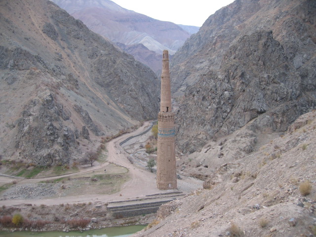
The Minaret of Jam is located in the centre of Afghanistan, 200 km east of Herat and 1,904 m above sea level, at the confluence of the River Harirud and its tributary the Jamrud, where three valleys converge, surrounded by mountain ranges that reach a maximum height of 2,300 m.The minaret was probably built between 1163 and 1203 in the reign of the Ghurid sovereign Ghiyas-ud-Din. The only monument to escape the destruction wreaked by Ghengis Khan, it remained unscathed and unknown for over seven centuries. The minaret itself and the archaeological remains surrounding it offer extraordinary testimony to the grandeur and refinement of the Ghurid civilization, which dominated the region in the twelfth and thirteenth centuries. Besides being an exceptional artistic testimony to twelfth-century Islamic culture, the Minaret of Jam also provides historical and political evidence about this isolated region near the most important commercial thoroughfare in Antiquity, linking Constantinople to India via Afghanistan, Herat and Kabul.
The discovery of this extraordinary monument occurred quite recently, as the first official mention of its existence goes back to May 1944, when Ahmed Ali Koazad, president of the Afghan History Society, published an article in the journal Anis relating a conversation he had had with His Excellency Abdullah Khan Malekyar, the Governor of Herat, who mentioned the Minaret of Jam to him, having been the first to discover and photograph it before 1943.
After its rediscovery in 1944, the minaret was again ‘lost from view’. Many expeditions were mounted to locate it in the ensuing years, but were unsuccessful due to the immensity of the territory and the difficult terrain. It was not until 19 August 1957 that the French archaeologist André Maricq finally found the minaret and published his discovery in the Mémoires de la Délégation Française en Afghanistan in 1958. In 1960, two envoys from DAFA (Délégation Archéologique Française en Afghanistan), Le Berre and his assistant Marchal, photographed the decorative panels and conducted an initial and very brief study of its architectural structure, uncovering the entrance with its two helicoidal stairways about 4 m below the current level.
The octagonal brickwork structure bonded with cement is about 60.41 m high (from the current level) and comprises three cylindrical ‘shafts’. The original entrance lies about 4 m below a layer of alluvial deposits and is currently inaccessible. Access to the minaret is via a narrow window giving on to one of the two helicoidal stairways that lead to the top of the first ‘shaft’ about 40 m up. The outside of the minaret is entirely covered in complex monochrome decoration in haut- and bas-relief. A special technique has been used to incorporate complex geometric designs, including quotations from verses of the Koran in Kufic script. The stylized inscriptions are a striking mix of vertical bands and circular tracings recalling a geometric floral design. Half-way up the minaret, a band of turquoise glazed tiling lends a unique touch of colour to the uniform brickwork surface.
The Minaret of Jam provides proof of the long architectural evolution of minarets in general. Eleventh-century minarets were circular (as in the Islamic Republic of Iran, at Isfahan and Barsiyan), but in Jam, the base is an octagonal structure of 9.05 m (according to the latest surveys conducted in October 2002) from which a 40 m high conical trunk emerges, the diameter decreasing nearer the summit (same survey 2002).
Risk of collapse
Aware of the monument’s importance and the lack of precise data regarding its conservation status, at the beginning of the 1960s the Afghan Government commissioned ISMEO (Istituto Italiano per il Medio ed Estremo Oriente, Rome), which was already working in Afghanistan, to undertake some research. Its task was to collate as much information as possible in order to draw up a programme to safeguard the minaret. A survey was also required with a view to creating an access route for the means of transport crucial to the restoration tasks. In September 1961, being an architect myself, I was commissioned by ISMEO to carry out the first survey of the minaret and put forward a protection and restoration programme that included consolidation of its base. At that time conservation of the monument was seriously jeopardized given the risk of collapse from river erosion of the base, causing it to list on its axis. As the projected action required an examination and preliminary analysis of a considerable amount of data, it could not be undertaken hastily, especially bearing in mind the difficulties of reaching the site.
In September 1962, during a second inspection mission to Jam, I discovered vestiges of an ancient necropolis in the vicinity of the minaret; including stones with inscriptions in Hebrew. The inscriptions were subjected to a thorough study by Prof. G. Gnoli (ISMEO) and may yield useful indications as to the exact location of Firuzkuh, the Ghurid capital.
Prior to that, Ahmed Ali Kozad had been the first to put forward the hypothesis that the site of the minaret might be that of Firuzkuh, the former capital founded by Qutb ul-Din Mohamad between 1145 and 1146 during his short-lived reign. The city’s exact location is still a mystery and, as André Maricq points out, traditional sources are hardly helpful as most Arab geographers lived before the city had been founded and only one of them places Firuzkuh between Herat and Ghazni. Although it is not known whether the Jam site really is the former location of Firuzkuh, it was definitely a fortification against possible invasions, a stronghold established at an exceptional strategic point on the route between Ghor and Herat.
The minaret was probably built at the height of the Ghurid dynasty, even though no date is mentioned in the inscriptions. The name of Ghiyath al-Din appears three times, and, according to certain historical texts, there was apparently a mosque there in 1192-93, which might have been destroyed on the orders of Ghengis Khan in 1221 or carried away by a river spate. Geologist A. Borgia’s recent mission (August 2002) uncovered evidence to confirm that hypothesis in the form of the 4 m layer of alluvial deposits covering the base of the minaret. This finding should be studied carefully by future missions. Decisions regarding the best way to restore the minaret cannot be taken until a thorough survey has been conducted.
To prevent other threats to the stability of the minaret, whose base is threatened by river erosion, protective traditionally built gabions of stones and tree trunks were set in place with the aid of the inhabitants from the neighbouring village in August 1963.
In June of the following year a brick and mortar sampling programme was conducted, but it was impossible to carry out surveys of the subsoil due to the complexity of the problems that had to be dealt with, including lack of machinery and of specialized personnel.
Many actions were undertaken at the end of the 1960s to reach the minaret from the village of Jam along the Jamrud and a wooden bridge was built across the Harirud to access the Bedam Valley.
In 1974, at the request of the Afghan Government and within the framework of the UNESCO-UNDP Project (Restorations of Monuments in Herat – Strengthening Government’s Capability for the Preservation of Historical Monuments) UNESCO commissioned me to undertake a thorough restoration study of the minaret as I was already in Herat at the time. Only then, thanks to the opening of a road suitable for vehicles, was it possible to plan a restoration project and finally transport the equipment and materials needed to the foot of the minaret. A small house was built alongside the monument to accommodate the labour force, as well as a warehouse for the building materials.
A break in the project
Between 1975 and 1980, when the citadel and minarets in Herat were being restored and a team of Afghan architects and engineers specializing in restoration work was set up, UNESCO financed an emergency intervention in Jam (in 1978) that was to involve installing protective metal gabions imported by sea and road from Europe, a step that was to be the first phase of the project. The gabions were to be filled with stones from the site to protect the base of the minaret against river erosion, but they were also meant to facilitate surveys and digs in order to obtain better archaeological information about the site before starting work to reinforce the base and foundations.
By September 1979, stones had been accumulated near the minaret. This initial operation, as well as the testing of the minaret’s foundations and the clearing away of the debris around the base, was to be completed the following year. Shortly afterwards, however, when the conditions required for action had finally been met, war broke out and made any further intervention impossible.
During the Soviet occupation, while UNESCO continually expressed its interest in conserving Afghan cultural heritage and in particular the city of Kabul and its archaeological museum, it was never able to take effective action. The question of safeguarding the monument was delegated to non-governmental organizations, especially the Society for the Preservation of Afghanistan’s Cultural Heritage (SPACH), an organization based in Peshawar, which for all those years did very useful work involving documentation and emergency actions. It continually drew attention to the problems of conservation in dramatic conditions in which the priorities were of a quite different nature.
Contact renewed
It was not until 1999 that the minaret received any serious attention and a new mission was carried out following a report from SPACH highlighting the dangers that threatened it. Twenty years after the last visit, under Taliban rule, I was able to reach the minaret on 2 August 1999, together with the Afghan engineer Akbari, thanks to a special agreement between the warring parties – Mujahidin and Taliban – who were entrenched on either side of the Harirud.
Although that inspection visit lasted barely an hour, after which the experts were forced to leave in order to avoid security problems that might have compromised the mission’s success, it achieved its ultimate objective, which was to check the state of the minaret and as far as possible compare it with the situation in 1979. In that short time, a decision was taken on the kind of emergency action that was feasible under the circumstances. Those twenty years which had seen a series of tangible interventions making it possible to prepare for the protection and restoration of the minaret and organize archaeological research throughout the area, had been followed by twenty more years (1979-99) of senseless destruction. Thus, by 1999 all the achievements of 1963-79 had been wiped out.
The last twenty years of ‘holding one’s breath’ had led to a particularly difficult situation and shattered all hopes of swiftly ensuring effective protection for the minaret. The bridge, base camp and infrastructures which should have served as a worksite depot were completely destroyed; the metal gabions provided by UNESCO in 1978 had disappeared, as had the protective materials installed in the 1960s; only the stones that had been gathered to fill in the gabions remained.
We had, in other words, reverted to the situation that prevailed prior to 1960, one of complete isolation from the civilized world. After thirty years of care and effort, work had to begin again from scratch, and, what is more, in a situation of armed conflict.
During that brief mission, in agreement with the Afghan engineer, who made himself available to supervise the work, a decision was taken to reuse the remaining stones and, in the absence of metal gabions, to use tree trunks to provide the minaret with temporary protection. As in 1961, the necessary labour was recruited in the area around the village of Jam. However, the idea of reconstructing the house and bridge as in the 1970s was ruled out lest they serve as military positions against the opposition forces (those of Commander Massoud).
In 1999 and 2001 SPACH and HAFO (Helping Afghan Farmers Organization) carried out protective measures in two phases. In the absence of gabions, the first phase involved an effective use of wood and stone (they successfully withstood a flood on 14 April 2002), while the second phase involved the use of metal gabions along the bank of the Harirud.
On course again
In March 2002, after the destruction of the Bamiyan Buddhas and the fall of the Taliban regime, UNESCO was again able to take over direct control of the situation and send a consultant to the site in a UN helicopter. Although the visit confirmed that the measures taken to protect the minaret’s base had proved successful, it also revealed the disastrous results of illicit excavations that would seriously jeopardize the scientific results anticipated from the projected archaeological digs. Judging by the scale of the clandestine digs, those responsible for them must have made a huge profit. What precisely has disappeared cannot yet be determined. A project to build a road and a bridge also presents a threat to the archaeological site as it might destabilize the minaret and would ruin the archaeological zone.
The gravity of the situation justified urgent action to safeguard the monument. This was the strongest argument put forward during the International Seminar on the Rehabilitation of Afghanistan’s Cultural Heritage, organized by UNESCO and the Ministry of Information and Afghan Culture in Kabul on 27-29 May 2002.
Meanwhile, UNESCO World Heritage Centre and the Afghan authorities elaborated a nomination dossier, including important information obtained from the March 2002 mission report. The Government of Afghanistan showed exemplary commitment and dedication in this endeavour. It nominated the site for inscription on both the World Heritage List and the List of World Heritage in Danger for consideration by the International Council on Monuments and Sites and the World Heritage Committee at their 26th session in Budapest (24-29 June 2002). This led to the first inscription of an Afghan property on the World Heritage List. Recognizing the urgent need to mobilize international technical and financial support to protect the property, the Committee accepted the government’s wishes to immediately inscribe the site on the List of World Heritage in Danger.
In the wake of the serious destruction wrought in the Bamiyan Valley (particularly that of the giant statues of Buddha) and the partial destruction of Kabul Museum, the Minaret of Jam has become a symbol. There is consequently room for cautious optimism concerning the future of Afghanistan’s cultural heritage.
Inclusion of the minaret on the World Heritage List has allowed UNESCO to initiate protection work by setting up a working group entrusted with the task of ensuring the monument’s preservation and enhancement.
In August 2002, I headed a mission that defined the basis necessary for an accurate survey of the area, the water courses and a more complete study of the foundations with the co-operation of a specialized geologist, Dr A. Borgia.
Following upon that mission, in October of that same year UNESCO commissioned a team with state-of-the-art equipment to carry out the second survey of the minaret to be conducted in the last forty years (the only previous survey was the one I had undertaken in 1961). That mission yielded a very positive result, providing UNESCO with plans of the minaret and with various precise measurements of its height, the cross-sections of the walls, the exact incline of its axis and site topography.
Those surveys and, above all, the measurements of the exact incline, are essential data for those responsible for planning consolidation work. Prof. Macchi, an engineer specializing in structural problems of such buildings as the Tower of Pisa and the bell tower of the basilica of St Marks in Venice, has been commissioned to prepare a consolidation project for the minaret. The first part of the project consists in a series of soundings of the foundations by means of core-drill boring and a structural study to be conducted by specialized companies in April 2003. This information will also be indispensable in deciding where to build a road without destabilizing the ground around the minaret.
Archaeological research will be undertaken at the same time, beginning with a thorough examination of the clandestine digs to obtain enough information to allow Afghan archaeologists to excavate in a scientific fashion. Italian archaeologists from ISIAO (Istituto Italiano per l’Africa e l’Oriente), under the supervision of Prof. G. Verardi, will join them in that task. In the meantime, the house near the minaret will have been rebuilt to serve as headquarters for the personnel of the restoration and archaeology mission.
Those initial actions will precede the main restoration project, which will involve other specialists and all necessary material and machinery.
It is to be hoped that the political situation in Afghanistan will allow UNESCO, the Afghan Government and the various specialists to pursue their efforts and carry out their missions in suitable conditions.
See this website for the results of the two seasons of rescue archaeology an international team of archaeologists was able to complete at the site in 2003 and 2005:
http://www.arch.cam.ac.uk/~alg1000/mjap/
An awesome Minaret… I never thought that there’s a such awesome Islamic building deep in the middle of Afghan. A nice article also. Thank you.
Hello Lara,… no I’m not archaeologist. You can read me by using the translator of Google. The language I am used to use is Spanish.
You have outlined a great details of the Minaret of Jam here… I have learnt a lot, your article beats that of wiki. Knowing so much details of this place makes me wonder are you an archaeologist.
I tried a about u page in your site, but most of the part was in other language and I couldnt get hold of it.
Wonderfull article about the hardly known Minaret of Djam
thanks a lot to let us know the inside of the problem of archeological conservation in Afghanistan noowdays.